Global Radar 
WORLD RADAR IMAGES
Global Radar Archive 
ARCHIVED IMAGES
Precipitype 
CURRENT RAIN/SNOW
Radar 
LATEST RADAR IMAGES
Radar Archive 
ARCHIVED IMAGES
Settling Snow Radar 
MELT OR SETTLE?
Storm Radar 
STORMS POSSIBLE?
Tornado Radar 
TORNADOES POSSIBLE?
Upwind Rainfall 
RAIN UPWIND OF YOU
Wind Radar 
WET N WINDY
Airmass 
AIRMASS SATELLITE IMAGES
Cloud Height Satellite 
HOW HIGH IS THAT?
Cloud Type Satellite 
FLUFFY OR NOT?
Fog Satellite 
FOGGYSAT
Global Satellite 
WORLD SATELLITE IMAGES
IR Satellite 
HI RES IR SATELLITE
Satellite Archive 
ARCHIVED IMAGES
Snow Satellite 
SPACE LAMPPOSTS
Storm Satellite 
THUNDERSTORM SATELLITE
Visible Satellite 
HI RES VISIBLE SATELLITE
Water Vapour Satellite 
HI RES WV SATELLITE
CycloneTracker 
TRACK ATLANTIC CYCLONES
Hurricane Centre 
LATEST ATLANTIC HURRICANES
Hurricane Hunters 
LIVE DATA
Live Aeroplane Data 
LIVE AMDAR DATA
Live Weather Map 
LIVE WEATHER PLOTTED ON A MAP
METAR/TAF 
AIRPORT WEATHER
Observation Archive 
ARCHIVED DATA
Rainfall Archive 
DID IT RAIN?
StormTracker 
THUNDERSTORM TRACKER LIVE
WeatherCams 
EYE SPY
Lightning Archive 
ARCHIVED DATA
Lightning Strikes 
LIVE LIGHTNING STRIKES
Past Hour Lightning 
LAST HOUR
Yesterdays Global Lightning 
BANG! CRASH!
Aurora Forecast 
NORTHERN LIGHTS
Latest Sun Image 
BIG YELLOW BALL
Space Station Passes 
TIMES/WEATHER ISS
Sun/Moon Times 
SUN/MOON TIMES AND PHASES
FogScanner 
PLAY MISTY FOR ME
GaleScanner 
BIT BLOWY
Rain Scanner 
RISK OF RAIN
Snow Scanner 
RISK OF SNOW
Storm Scanner 
RISK OF STORMS
Above Me Now 
WHERE EAGLES FLY
Atlantic Storms 
OUR STORM NAMES
Freezing Level 
SHOWING SNOW/RAIN LEVEL
GDAS Observations 
GFS MODEL OBS DATA
Metcheck CET 
CENTRAL ENGLAND TEMPERATURE
Teleconnections 
NAO/AO ETC


Chance Of Clear Skies 
MOON AND STARS?
Clear Air Turbulence 
BUMPY LANDINGS?
Frost Maps 
LATEST FORECASTS FOR FROST/ICE
GHX Risk Charts 
RISK OF RAIN MAPS
GHX Risk Charts Ext 
30 DAY RISK MAPS
Haines Index Charts 
WILDFIRE RISK
Humifeel Charts 
HOT AND SWEATY?
Probability Charts 
557WW PROBABILITIES
Snow Maps 
RAIN OR SNOW?
Storm Maps 
THUNDERSTORMS EXPECTED?
UV Index Forecast 
SLIP SLOP SLAP
Visibility Charts 
MIST/FOG
Weather Alarm Global 
HIGH RES ADVERSE WEATHER
Weather Alarm Regional 
HIGH RES ADVERSE WEATHER
Weather Charts Archive 
ARCHIVED CHARTS
Weather Icon Charts 
ICON BASED CHARTS
Air Quality/Pollen 
ATCHOO! COUGH!
Average Temperatures 
WHATS THE NORM?
Calendars 
ADD FORECASTS TO CALENDARS
Climatic Deviation 
WARMER OR COLDER?
Cloudwatch 
CLOUD CROSS SECTION
Ensemble Data 
MODEL ENSEMBLES
Ensemble Risk 
RISK OF RAIN ETC
Ensemble Risk Ext 
30 DAY RISK OF RAIN ETC
Global Forecasts 
GLOBAL FORECASTS
Laundry Drying 
PANTS REALLY...
Next Month 
NEXT MONTH OUTLOOK
Pollen Type Forecasts 
TREE AND GRASS POLLEN
Skew-T Forecasts 
ATMOSPHERIC PROFILES
Snowwatch 
SNOW FORECAST DATA
Stormwatch 
STORM FORECAST DATA
The Week Ahead 
WEEK AHEAD AVERAGES
The Year Ahead 
UK SINGULARITIES
When Will It Next 
MODEL SCANNER


ARCUS 
SUPER ENSEMBLE CHARTS
ARPEGE 
METEO FRANCE
BAM 
BAM MODEL FROM CPTEC IN BRAZIL
ECMWF 
EURO MODEL
ECMWF AI 
EURO AI MODEL
GEM 
CANADIAN MODEL
GFS 
NCEP GFS MODEL
GFS Animated 
GFS ANIMATED
GFS Archive 
ARCHIVED CHARTS
Global Model Verification 
PREVIOUS FORECASTS FOR TODAY
ICON 
DWD MODEL
JMA 
JAPANESE MET AGENCY
NASA GEOS5 
NASA MODEL
NAVGEM 
NAVGEM
SL-AV Model 
RUSSIAN MODEL
ALADIN 
METEO FRANCE FOR UK
ALARO 
BELGIAN RMI MODEL
ARCUS UK 
UK SUPER ENSEMBLE
Arome 
METEO FRANCE FOR UK
Arome Caribbean 
METEO FRANCE FOR CARIBBEAN
Arome Indian Ocean 
HI RES FOR MAURITIUS
Arpege 
METEO FRANCE FOR EUROPE
GFS Regional 
HI RES PLUS DATA
HRRR 
NCEP FOR USA
ICON 
DWD MODEL
ICON D2 
DWD HI RES MODEL
NAM 
NCEP FOR USA
RAP Model 
NCEP FOR USA
RDPS Model 
CANADIAN MODEL
UK RAP Model 
NCEP HI RES MODEL
ECMWF Wave 
ECMWF WAVE
EMFWAM 
METEO FRANCE EUROPE
EWAM 
DWD EUROPE
GMFWAM 
METEO FRANCE GLOBAL
GWAM 
DWD GLOBAL
GWVE 
GFS GLOBAL
Sea Temperatures 
TEMPERATURES + ANOMALY
557WW Ensembles 
ENSEMBLE AVERAGES
CFS Ensembles 
ENSEMBLE AVERAGES
ECMWF Ensembles 
ENSEMBLE AVERAGES
GEM Ensembles 
ENSEMBLE AVERAGES
GFS Ensembles 
ENSEMBLE MODEL DATA
ICON D2 Ensembles 
HIGH RES ENSEMBLES
ICON Ensembles 
ENSEMBLE AVERAGES
ICON Europe Ensembles 
EUROPEAN ENSEMBLES
CanSIPS Seasonal 
SEASONAL CHARTS
CFS Seasonal Charts 
6 MONTH FORECASTS
Long Range Charts 
SUPER LONG RANGE WEATHER
Hurricane Models 
HI RES FLOATER MODEL
Tropical Weather Models 
TROPICAL MODEL OUTLOOK
Air Quality/Pollen Charts 
ATCHOO!
Dust Charts 
DUST/AEROSOL CHARTS
Jet Stream 
NCEP GFS JET STREAM
Jet Stream Archive 
ARCHIVED CHARTS
Stratosphere Forecasts 
UPPER AIR CHARTS
Synoptic Charts 
FRONTS AND ISOBARS


Forecast Challenge 
CHALLENGE US
Gallery 
USER PICTURE GALLERY
MyMetcheck 
MYMETCHECK
Weather Reports 
YOUR WEATHER REPORTS


Add Club Location 
ADD YOUR CLUB LOCATIION TO OUR DATABASE
Astronomy 
STARRY STARRY NIGHTS
Aviation 
UP UP AND AWAY
Camping 
CAMPING IT UP
Canoeing 
ESKIMO ROOOOLL
Climbing 
AFRAID OF HEIGHTS?
Cricket 
HOWZAT!
Croquet 
CROQUET WEATHER FORECASTS
Cycling 
I LOVE TO RIDE MY...
Diving 
DEEP BREATH
Fishing 
CHANCE OF A CATCH
Gardening 
PRUNING WEATHER
Golf 
HOLE IN ONE
Horse Riding 
GIDDY UP!
Jogging 
JOGGING WEATHER
Kiteboarding 
COAST WEATHER
Model Aviation 
MODEL AVIATION / ROCKET FORECASTS
Mountain Biking 
MOUNTAIN FORECASTS
Mountains & Hills 
MOUNTAIN RANGES
Paragliding 
WHERE EAGLES FLY
Polo 
HORSEY WEATHER
Rambling/Walking 
WEATHER FOR RAMBLING AND WALKING
Rowing 
LAKE WEATHER
Sailing 
INSHORE FORECASTS
Skydiving 
UPPER AIR FORECASTS
Surfing 
BEACH BREAK FORECASTS
Tennis 
TENNIS FORECASTS
Windsurfing 
BEACH FORECASTS
Air Shows 
FLY PASSES
Firework Displays 
BANG! WHOOSH! WEEE!
Royal Shows 
BULLS AND ROSETTES
Weekend Attractions 
WEEKEND ATTRACTIONS
Festivals 
ALL OUR FESTIVALS
Formula 1 
WEATHER FOR F1 RACES
Formula 1 E 
WEATHER FOR F1E RACES
MotoGP 
WEATHER FOR MOTOGP
Red Arrows Displays 
WHERE ARE THEY NEXT?
Red Arrows Live 
ROGER ROGER TANGO
Rugby Union 
RUGBY WEATHER
UK Football Leagues 
PREMIER ETC
World Football Leagues 
MORE FOOTBALL
Champions League 
EVERY MATCH FORECAST
Europa Conference 
EVERY MATCH FORECAST
Europa League 
EVERY MATCH FORECASTS
Horseracing 
FORECASTS AND CALENDAR
IPL Cricket 
HOWZAT!
UEFA Nations League 
CMON ENGLAND!
1000 Guineas 
1000 GUINEAS WEATHER
2000 Guineas 
2000 GUINEAS WEATHER
Army v Navy 
ARMY V NAVY WEATHER
Badminton Trials 
BADMINTON TRIALS WEATHER
Champions League Final 
CHAMPIONS LEAGUE FINAL WEATHER
Championship Playoff Final 
CHAMPIONSHIP PLAYOFF FINAL WEATHER
Chelsea Flower Show 
CHELSEA FLOWER SHOW WEATHER
Copa America 
COPA AMERICA WEATHER
Epsom Derby 
EPSOM DERBY WEATHER
Epsom Ladies Day 
EPSOM LADIES DAY WEATHER
FA Cup Final 
FA CUP FINAL WEATHER
Festival of Speed 
FESTIVAL OF SPEED WEATHER
ICC T20 World Cup 
ICC T20 WORLD CUP WEATHER
Indianapolis 500 
INDIANAPOLIS 500 WEATHER
Isle Of Man TT 
ISLE OF MAN TT WEATHER
Kentucky Derby 
KENTUCKY DERBY WEATHER
Le Mans 24 Hours 
LE MANS 24 HOURS WEATHER
London Marathon 
LATEST WEATHER FORECAST FOR LONDON MARATHON
Perth Races 
PERTH RACES WEATHER
Queens Club Tennis 
QUEENS CLUB TENNIS WEATHER
Roland Garros 
ROLAND GARROS WEATHER
Royal Ascot 
ROYAL ASCOT WEATHER
Scottish Open 
SCOTTISH OPEN WEATHER
The Open Championship NEW! 
THE OPEN CHAMPIONSHIP WEATHER
UEFA European Championship 
UEFA EUROPEAN CHAMPIONSHIP WEATHER
US Open Golf 
US OPEN GOLF WEATHER
Wimbledon 
WIMBLEDON WEATHER


Discussion Archive 
ALL OUR OLD DISCUSSIONS
Discussions 
METEOROLOGISTS DISCUSSIONS
Event Discussions 
METEOROLOGISTS DISCUSSIONS
Eye In The Sky 
HI RES SATELLITE STUFF
Eye In The Sky Archive 
LOADSA IMAGES
Frontpage Archive 
ALL OUR RAMBLINGS
GFS Commentary 
METEOROLOGISTS LIVE DISCUSSIONS
Global Discussions 
AROUND THE WORLD
Global Discussions Archive 
AROUND THE WORLD
Live Daily Feed 
LATEST WEATHER INFO
Live Discussions 
EXPERT IMAGE ANALYSIS
Snow Discussion 
OFFICIAL FORECAST
Snow Discussion Archive 
OLD SNOW DISCUSSIONS
Storm Discussion 
METEOROLOGISTS STORM DISCUSSIONS
Storm Discussion Archive 
OLD STORM DISCUSSIONS


Construction 
CRANES/CEMENT
Developers 
FREE DATA
Electricity Demand 
HDD/CDD
Farming 
FARMING FORECASTS
GHX Model 
OUR WEATHER MODEL
Retail Demand 
SALE NOW ON!
Weather Stickies 
WEATHER ON YOUR SITE


Search Metcheck


Latest Weather Reports

Visit ►

George from Lisburn ▼

 Following the overnight rain today was dry with long sunny spells and at present the sky i...

ian h from ewhurst ▼

 7.55 pm and just lit the fire perishing outdoors have a lovely evening probabl...

Anne from Jersey St Helier ▼

 Update A lovely sunny 🌞 afternoon….BUT very chilly . 🥶 Must not grumble 😠. ...

Pages Now Trending

Visit ►
Aurora Forecast Northern Lights
Radar Latest Radar Images
Global Radar World Radar Images
Eye In The Sky Hi Res Satellite Stuff
Weather Alarm Global High Res Adverse Weather
Discussions Meteorologists Discussions
Live Discussions Expert Image Analysis
Lightning Strikes Live Lightning Strikes
◄► GFS Ncep Gfs Model
Formula 1 Weather For F1 Races

Wind And Rain Return From The West

Added : Saturday at 6:00


As far as the weather goes it is a weekend of two halves for much of Britain and Ireland as milder but wetter and windier weather affect many areas during today and tonight before giving way to brighter but colder conditions tomorrow with wintry showers. The changeable weather is all thanks to an area of low pressure sweeping across the country during the next 24 hours or so and the unsettled theme looks set to continue into next week with further active systems pushing in.

It will be a bright and frosty start to Saturday across central and eastern parts of England but cloud is already thickening from the west in advance of outbreaks of rain that are currently affecting most parts of Ireland, Northern Ireland and Wales along with western regions of England and much of Scotland where snow is falling quite widely over higher ground. The band of rain, with hill snow in the north, continues to push eastwards this morning and although northern parts of Britain will become brighter with a few showers by this afternoon, the rain further south will link back to another area of heavy rain moving into Ireland, Northern Ireland, Wales and southwest England later this afternoon as a developing low approaches from the west. It will be a milder day across most regions with maximums in the range of 7°C to 12°C, mildest in the southwest, although it won't feel all that mild in the rain, but for Scotland it will be colder with values held back in the low single figures.

A wet and windy evening and night follow for much of central and southern Britain and Ireland with that deepening low bringing the risk of gales for a time and perhaps some snow to southern Scotland. However for central and northern Scotland it will be cold with wintry showers around the coasts and by dawn tomorrow that clearer, colder weather will have extended to just about all areas. This sets us up for a cold and blustery Sunday with a mixture of sunny spells and sleet or snow showers, the showers mainly in the north and west but they will be spreading further inland at times too.

METEOROLOGIST: BARBER

Please read our terms and conditions of using this site before copying or distributing any of our articles/discussions or forecasts.

GHX ► Radar ► 2018 Winter Olympics ► The Six Nations ► 


Help & Information

New Today On Metcheck

1 NEW frontpage article
- High Pressure Starts To Build

1 NEW discussion
- Read ►

1 NEW global discussion
- Read ►

1 NEW MAY BANK HOL discussion
- Read ►

1 NEW live discussion
- Read ►

52 NEW weather reports
- Read/Add ►

1 NEW Eye In The Sky image
- View ►

1 NEW GFS Commentary
- Read ►

1 NEW snow discussion
- Read ►

Heading into the second half of April and the weather still thinking it's the middle of March...

Added : 10 hours ago

Moisture and clouds off the West Africa coast, showers for the UK and low pressure approaches the Himalayas....

Added : 7 hours ago

Patchy showers across Northern and Northeastern areas this morning as a trough moves South...

Added : 18 hours ago

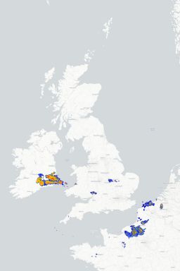
Want to see where precipitation is dropping out of the sky right now across the UK? No worries, check out the 15 minute radar below which loops through the last 6 hours of information.

Toys Similar To This :-

Whoah! How clever is this? The Metcheck Thunderstorm Tracker Satellite allows you to see the developing storms across Western Europe and tells you whether they are growing or decaying. Every 15 minutes we take a snapshot of the cloud cover then measure the temperature and height of the clouds and show you whether the area of clouds are developing into thunderstorms and what direction they are moving in.

Toys Similar To This :-

Live weather data from around the country displayed on Google Maps

Toys Similar To This :-

These are the latest NCEP GFS model weather charts at Metcheck.

Toys Similar To This :-

You probably hear a lot about the Jet Stream in the news. It's either too far North or too far South. The jet stream is identified as winds at 300mb (during Winter) and 200mb (during Summer). It is these winds which are responsible for driving and developing weather systems across the Atlantic.

Metchecks own GHX model charts out to 240 hours ahead

Toys Similar To This :-

The Metcheck 7 Day Forecast takes the best from the GFS weather models and displays it in easy to read maps for the UK out to the next 192 hours ahead.

The Metcheck 7 Day Forecast takes the best from the GFS weather models and displays it in easy to read maps for the UK out to the next 192 hours ahead.

Showing you where frost and ice is expected to develop out to 16 days ahead.

Toys Similar To This :-

Pages Now Trending

Visit ►
Aurora Forecast Northern Lights
Radar Latest Radar Images
Global Radar World Radar Images
Eye In The Sky Hi Res Satellite Stuff
Weather Alarm Global High Res Adverse Weather
Discussions Meteorologists Discussions
Live Discussions Expert Image Analysis
Lightning Strikes Live Lightning Strikes
◄► GFS Ncep Gfs Model
Formula 1 Weather For F1 Races