Stu (by the Thames) Sent in this image from Tilbury
Evening again...therre was clearer gaps towards dusk but there was still lumpy cloud to the NE. A current temperature of 16.0c with winds W'rly in direction and gusting to 35mph.
Image sent in by Stu (by the Thames)
Evening again...therre was clearer gaps towards dusk but there was still lumpy cloud to the NE. A current temperature of 16.0c with winds W'rly in direction and gusting to 35mph.
Stu (by the Thames) Sent in this image from Tilbury
It soon brightened up again though with the fresh WSW'rly persisting. A current temperature of 17.6c after a pleasant max of 19.9c with 1.2mm in the pot.
Image sent in by Stu (by the Thames)
It soon brightened up again though with the fresh WSW'rly persisting. A current temperature of 17.6c after a pleasant max of 19.9c with 1.2mm in the pot.
Stu (by the Thames) Sent in this image from Tilbury
Afternoon all...l did go back to London last evening but have had to rush back to S Essex this morning. My dad had a fall and couldn't get up. Paramedics called who, fortunately, arrived within 50 minutes. He was checked over and luckily didn't have to go to hospital. So l'm staying now tomorrow. It's not easy trying to balance work and homelife too. And being an only child it comes with an extra challenge. Weatherwise, it's been bright & breezy with a current temperature of 19.4c and WSW'rly gusts to 35mph.
Image sent in by Stu (by the Thames)
Afternoon all...l did go back to London last evening but have had to rush back to S Essex this morning. My dad had a fall and couldn't get up. Paramedics called who, fortunately, arrived within 50 minutes. He was checked over and luckily didn't have to go to hospital. So l'm staying now tomorrow. It's not easy trying to balance work and homelife too. And being an only child it comes with an extra challenge. Weatherwise, it's been bright & breezy with a current temperature of 19.4c and WSW'rly gusts to 35mph.
“Understood STU.
Glad to hear that your dad's not too bad.
I had the same onus with my late mother's dementia, but she looked after me when I was a kid with grazed knees, so, as I see it, what goes around, comes around. But I get the fact that with a family of your own - and work - you don't get a moment for yourself, which we know is very important... take care. 😉 Edited : Fri 9 Oct - 16:56”
Antonio Commented 3 hours ago
“Sorry to hear this STU....here's hoping your Dad makes a full and speedy recovery. ”
Sarah Commented 3 hours ago
“That's tough to balance. All priorities. Hospital may have home help / short term carer ideas ... I know your dad wants to be strong but he may have to accept assistance from others with this medical need. No, he won't want to go to hospital. You'll be ok STU. Have a cuppa and look at the sky x Edited : Fri 9 Oct - 16:23”
David from L.E Commented 2 hours ago
“Really sorry to hear about your problems. I hope things improve.”
Stu (by the Thames) Commented 2 hours ago
“Cheers all...it's true RICK. Definitely a sense of a responsibility to be there for them👍🏻. We're to get in touch with the GP, SARAH, to start the ball rolling in getting help, a care line. They are both fiercely independent, so accepting help is not easy for them. But cloud watching and a tea has helped 😌 ”
Mike O.S.B. Sent in this image from 50.4701/-3.5305
.
Good Morning everyone, welcome to Friday and to the last day of work and school for many. I wish you an excellent day in all respects.
-
Here is my Weather Report for today for Torquay:-
-
BAROMETRIC PRESSURE
.
Current Barometric Direction:- Recently falling now steady.
Barometric Pressure (mb.) and Direction at this time yesterday:- 1026.2. Steady.
-
PRECIPITATION
.
Total Amount (mm.) and Type of Precipitation to date:- 6.06 Rain
-
SUN HOURS
.
Sun Hours received yesterday:- 8.0
Total Sun Hours received this month so far:- 41.0
-
SUNRISE AND SUNSET
.
Sunrise (a.m.) :- 7:26
Sunset (p.m.) :- 6:35
-
TEMPERATURE
.
Yesterday’s Maximum Temperature (deg. c.) :- 16.5
Today’s Expected Maximum Temperature (deg. c.) :- 17.0
Yesterday’s Minimum Temperature (deg. c.) :- 8.5
-
WIND
Yesterday’s Strongest Wind Gust (m.p.h.) :- 10.2
Today’s Expected Strongest Wind Gust (m.p.h.) :- 35.0 from the West around 4:00 p.m.
-
REMARKS
None
-
BIBLE CORNER
.
Today in the English Benedictine Congregation’s Ordo is:- Saint John Henry Newman, Priest
More about this Saint can be found in Franciscan Media, Universalis or Wikipedia
The Liturgical Classification of today is:- Memorial
The Liturgical Colour of today is:- White
The Liturgical Reading of today is:- ‘Greater love has no one than this, that someone lay down his life for his friends.’
John 15: 9 - 17
-
DOMINUS VOBISCUM
🕇
Image sent in by Mike O.S.B.
.
Good Morning everyone, welcome to Friday and to the last day of work and school for many. I wish you an excellent day in all respects.
-
Here is my Weather Report for today for Torquay:-
-
BAROMETRIC PRESSURE
.
Current Barometric Direction:- Recently falling now steady.
Barometric Pressure (mb.) and Direction at this time yesterday:- 1026.2. Steady.
-
PRECIPITATION
.
Total Amount (mm.) and Type of Precipitation to date:- 6.06 Rain
-
SUN HOURS
.
Sun Hours received yesterday:- 8.0
Total Sun Hours received this month so far:- 41.0
-
SUNRISE AND SUNSET
.
Sunrise (a.m.) :- 7:26
Sunset (p.m.) :- 6:35
-
TEMPERATURE
.
Yesterday’s Maximum Temperature (deg. c.) :- 16.5
Today’s Expected Maximum Temperature (deg. c.) :- 17.0
Yesterday’s Minimum Temperature (deg. c.) :- 8.5
-
WIND
Yesterday’s Strongest Wind Gust (m.p.h.) :- 10.2
Today’s Expected Strongest Wind Gust (m.p.h.) :- 35.0 from the West around 4:00 p.m.
-
REMARKS
None
-
BIBLE CORNER
.
Today in the English Benedictine Congregation’s Ordo is:- Saint John Henry Newman, Priest
More about this Saint can be found in Franciscan Media, Universalis or Wikipedia
The Liturgical Classification of today is:- Memorial
The Liturgical Colour of today is:- White
The Liturgical Reading of today is:- ‘Greater love has no one than this, that someone lay down his life for his friends.’
John 15: 9 - 17
-
DOMINUS VOBISCUM
🕇
Ian near Rye Sent in this image from 51.0174/0.7062
Good morning everyone,
A cloudy start with the most noticeable point being the 10 plus degree difference yesterday's 5 * C and this mornings 16.7* C ! Firmly in the warm sector before the cold front moves through this afternoon. 1mm in the pot overnight as the warm front passed over .
Have a good day 😊
Image sent in by Ian near Rye
Good morning everyone,
A cloudy start with the most noticeable point being the 10 plus degree difference yesterday's 5 * C and this mornings 16.7* C ! Firmly in the warm sector before the cold front moves through this afternoon. 1mm in the pot overnight as the warm front passed over .
Have a good day 😊
Cloudwatcher Sent in this image from -33.7473/150.6463
Good morning everyone from Emu Plains ,
Some have beaten me to it but have a very , merry Happy Birthday DAVID 🎉🍻 !
Over here it has been a lovely day , the sky has kept blue with some cirrus appearing late to our west ! Wind was light becoming gentle northeasterly late and we did warm up to a high of 30.5 c at 5 12 pm !
We have a messy trough and cold front coming through in the morning , after a clear evening , we may get some early showers or storms with wind picking up moderate to fresh NW/ W during the day . A forecast low of 14 c tonight !
Enjoy 👍
Image sent in by Cloudwatcher
Good morning everyone from Emu Plains ,
Some have beaten me to it but have a very , merry Happy Birthday DAVID 🎉🍻 !
Over here it has been a lovely day , the sky has kept blue with some cirrus appearing late to our west ! Wind was light becoming gentle northeasterly late and we did warm up to a high of 30.5 c at 5 12 pm !
We have a messy trough and cold front coming through in the morning , after a clear evening , we may get some early showers or storms with wind picking up moderate to fresh NW/ W during the day . A forecast low of 14 c tonight !
Enjoy 👍
When Metcheckers aren't getting their latest weather fix on the site they tend to be taking stunning pictures of clouds. After all, we all love looking at beautiful sunsets, mist on a spiders web and clouds shaped like thingies don't we?
Take a look at the latest images uploaded and if it inspires you to take some picture then please feel free to upload them by using the feature at the bottom of the page.
Taken a great weather photo?
It's so easy to upload it to our gallery. All you have to make sure is that the image is a jpeg and on your hard drive. Then select the image, click upload and we'll create a thumbnail and full size image for all Metcheck viewers to enjoy.
The global models are starting to edge away from the idea of a more dominant ridge across the UK with more unsettled weather...
Added : 9 hours ago
Thunderstorms today in Iraq, the UK today with a cold front moving Southeast and Hurricane Isaias now a major hurricane and approaching the Gulf Coast with landfall tonight...
Added : 4 hours ago
Showers across Northwestern areas this evening as the cold front clears Southeast...
Added : 55 minutes ago
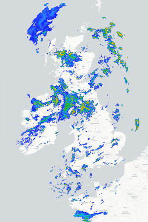
Want to see where precipitation is dropping out of the sky right now across the UK? No worries, check out the 15 minute radar below which loops through the last 6 hours of information.
Toys Similar To This :-
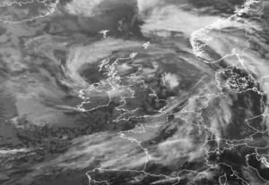
Whoah! How clever is this? The Metcheck Thunderstorm Tracker Satellite allows you to see the developing storms across Western Europe and tells you whether they are growing or decaying. Every 15 minutes we take a snapshot of the cloud cover then measure the temperature and height of the clouds and show you whether the area of clouds are developing into thunderstorms and what direction they are moving in.
Toys Similar To This :-
Live weather data from around the country displayed on Google Maps
Toys Similar To This :-
These are the latest NCEP GFS model weather charts at Metcheck.
Toys Similar To This :-
You probably hear a lot about the Jet Stream in the news. It's either too far North or too far South. The jet stream is identified as winds at 300mb (during Winter) and 200mb (during Summer). It is these winds which are responsible for driving and developing weather systems across the Atlantic.
Metchecks own GHX model charts out to 240 hours ahead
Toys Similar To This :-
The Metcheck 7 Day Forecast takes the best from the GFS weather models and displays it in easy to read maps for the UK out to the next 192 hours ahead.
The Metcheck 7 Day Forecast takes the best from the GFS weather models and displays it in easy to read maps for the UK out to the next 192 hours ahead.
Showing you where frost and ice is expected to develop out to 16 days ahead.



 Good evening guys, Conditions here at the moment is dry with clearer skies, just seeing th...
 Gosh - it's raining 'Datsun Cogs' at the moment but shouldn't last that long as the front ...
 Very heavy squally rain just now in the Candover valley, and looking to the west it...