Atlantic Storm BrewingAdded : Saturday at 12:30 Attention turns to the Atlantic during Tuesday as a rapidly developing area of low pressure deepens to the southwest of the British Isles before pushing northwards. There remains some uncertainty over its exact track and depth, but the system is expected to become a significant feature as it approaches from the west, tightening the pressure gradient across Britain and Ireland and bringing an increasingly strong southerly airflow :-
![]()
![]()
![]()
Current guidance suggests the central pressure could fall by more than 24mb in just 24 hours as the system undergoes a period of explosive cyclogenesis, rapidly developing into a very deep and potentially powerful Atlantic low.
Ahead of the low, a plume of warm and increasingly moist air will be drawn northwards across the country. This should result in a marked rise in temperatures, particularly across England and Wales, where highs into the mid-twenties are possible despite increasing amounts of cloud :-
![]()
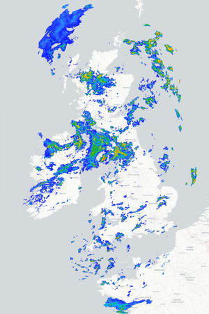
At the same time, associated frontal systems will begin pushing into Ireland and western Britain bringing outbreaks of rain, locally heavy and persistent, accompanied by strengthening winds. The wettest and windiest conditions are expected across western and northwestern areas, while eastern Britain remains drier and very warm for longer :-
![]()
Fortunately, the core of the low currently looks set to remain well to the west of the British Isles, with some guidance deepening the system to around 951mb by Wednesday. Storm-force winds are possible around its southern flank, although the strongest winds should remain over the open Atlantic provided the low follows its currently expected track :-
![]()
The low remains influential into Wednesday as its associated frontal systems continue eastwards, bringing further spells of rain and strong winds before cooler and fresher air begins to spread in from the west :-
![]()
METEOROLOGIST : BARBER |